Saturday, December 04, 2010

Kop van Zuid, Urban Planning Case Study in the Netherlands [Writing for Master Course, 2007]


This paper work is a continuation from the previous post: Introduction of Urban Planning: Urban Design Methods and Theories [Writing for Master Course, 2007]
, an assignment submitted for the Master study course Urban Design Methods and Theories of the Department of Urbanism, Faculty of Architecture, Delft University of Technology (TU Delft). This writing is not the full version of the assignment, only one case study are showed.


Kop van Zuid


Kop Van Zuid Area View


Overview of Regeneration Scheme
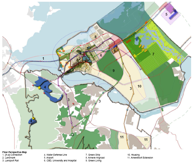
Kop van Zuid (“Southern Headland”) is a peninsula on the south bank of the River Maas directly opposite Rotterdam’s city centre. It covers some 125 ha and used to be an important port area with docks, a shipyard and a terminal for ocean-going liners, but all these activities closed down when the port moved downstream to the mouth of the river during in the 1960s and 1970s, and Kop van Zuid became abandoned. It was an isolated and largely hidden area, cut off from the river by warehouses and from surrounding areas by railway lines, and was poorly connected to the city centre. The wider area in which it lies, the ‘borough’ of Feyenoord (one of Rotterdam’s 13 sub-municipalities), consists mainly of poor residential neighborhoods where the people who worked in the port and other riverside industries used to live. It now has a high level of immigrants among its population. It has traditionally been an area of low educational achievement and high unemployment, and it used to have a very poor image, which made it difficult to attract private investment or people with choice to live there.


Satellite Map of Rotterdam (top) & Kop Van Zuid Location (bottom) 


There were plans to redevelop the area for social housing, but in 1986, under a master plan commissioned by the new City Planning Director Riek Bakker, Kop van Zuid became seen as a key to unlocking huge potential for the whole city. If it was developed as a high-quality mixed-use area, with eye-catching buildings and a lively waterfront, and connected directly to the city centre, it could not only change Rotterdam’s image but also open up the entire south side of the city.


Kop Van Zuid Area Map:
1. North bank-city centre
2. Erasmusbridge
3. The district Noordereiland (an isle in the river, belonging to the borough of Feijenoord),
4. Wilhelminapier (KvZ Area-belonging to the city centre)
5. Zuidkade (KvZ Area-belonging to the city centre)
6. Landtong (KvZ Aera-belonging to the city centre)

The plan for Kop van Zuid aimed to create a series of distinctive buildings and quarters in order to broaden the population and create new jobs in the area. Two university colleges with 10,000 students were built. The plan provided for 5,300 residential units and 400,000 sq.m. of offices, but it was flexible enough to accommodate changes in the mix as the housing market gained in strength. The redevelopment has been carried out under a phased strategy spread over several years. Although only the first part of the scheme has been completed, it has already had a dramatic impact on the area and on Rotterdam.


Hotel New York by Night


Reuniting a Divided City
The Erasmus Bridge, the new Metro station in Kop van Zuid and extension of the tram system have linked the north and south sides of the city much more closely. By putting the main railway lines underground, the pedestrian links with the adjoining residential areas have been greatly improved, and new suburban stations have helped improve local accessibility. There is also a popular system of water taxis which cross the river and link up with various visitor attractions. Kop van Zuid is now only a few minutes from the city centre which is also now well-connected to the rest of south Rotterdam. People from the north of the river now visit the South Bank, and many of the new residents of Kop van Zuid have come from across the river as well as from the wider region. The high quality of the public realm, with direct pedestrian routes and high quality surfaces, has helped to attract people with higher incomes to live in the area, thus helping to rebalance the demographic profile, and rising property values are encouraging existing residents to stay, as the whole area is definitely ‘on the up’.


The Louis Pregerkade and the Binnenhaven


Changing the City’s Image
Apart from the bridge, Kop van Zuid now has a number of stunning buildings. Many were designed by leading architects such as Renzo Piano, Norman Foster and Rem Koolhaas. Historic older buildings too have been restored and re-used. For example, the former Holland America line terminal has been converted into the atmospheric Hotel New York, and the oldest dock in the area has been turned into an industrial museum. The Entrepot building became a supermarket and a series of restaurants with food from around the world, so as to retain some of its previous character. Although the restaurants failed as insufficient demand had yet built up, the scheme succeeded in changing the area’s image and in attracting private investment in high quality housing.

 World Port Center, Hotel New York and Montevideo

High quality urban design has also been a notable feature (supported by Dutch planning policy in general and by Kop van Zuid’s Quality Team). Public art is used imaginatively to interpret the area’s history. The waterside has been opened up to people on foot. There is good lightning, a minimum of street clutter, and imaginative use of shared surfaces, with ample street parking in most residential areas combined with wide tree-lined pavements. The streets are kept scrupulously clean by gangs of cleaners and by the use of large receptacles into which rubbish has to be put.


Francine Houben’s Montevideo


Repositioning Rotterdam
The redevelopment of Kop van Zuid as a high quality mixed-use area close to the city centre is playing an important part in repositioning Rotterdam’s economy by making the city attractive to modern industries and to the people who work in them. Back in the 1980s the city feared that it could never compete with Amsterdam or The Hague as an office centre, let alone as a place for creative businesses. However this has now started to happen. Rotterdam was cited as one of the examples of urban renaissance by the Urban Task Force, and it won recognition as European Capital of Culture in 2001. Unemployment has fallen from 17% in 1991 to 6% in 2005 and the population of the city is slowly rising again. Much of the new employment has been created in the north west of the city (towards the airport) and many of the jobs in Kop van Zuid are in organisations that have relocated there from other parts of the city. What has succeeded in a big way is the new housing, and it has helped in attracting people with good jobs to live in the city. 40% of the residents of the area come from outside the region. These people are attracted by the prestige and convenience of the location. Furthermore, as Amsterdam is becoming more expensive and less accommodating of unconventional behavior, so Rotterdam with its new image is becoming the place for creative people to be. This is exactly what is required to reposition Rotterdam as not just a port but also a dynamic city for the 21st century.


The New Luxor Theatre by Night


Spreading the Benefits
In the Netherlands a high priority is given to social programmes. The growth in immigration of people with low skills, combined with the changing labor market, put major pressures on Rotterdam, particularly in areas like Feyenoord. While the redevelopment of Kop van Zuid was aimed at repositioning Rotterdam for the future, there was a danger that it might leave the poorer communities right next to it largely unaffected. When the plans for Kop van Zuid were first made  public, there was concern in the City Council and among the local neighborhood associations over the problems that might be caused by putting luxurious development next door o deprived areas. It was therefore agreed that a concerted effort would be made to ensure that the project also created benefits for local people. The neighborhood associations were included in the project organization, and a Mutual Benefit programme was developed to help channel as many as possible of the jobs generated by the development to local people and to improve the economies of the surrounding areas.


Delft, January 2007
Sigit Kusumawijaya


Urban Design Methods and Theories: Introduction of Urban Planning
Writer: Sigit Kusumawijaya
Supervisor: Ir. Willem Hermans
Status: assignment submitted for the Master study course
Urban Design Methods and Theories of the Department of Urbanism, Faculty of Architecture, Delft University of Technology (TU Delft)
Year: 2007

Sunday, November 28, 2010

Introduction of Urban Planning: Urban Design Methods and Theories [Writing for Master Course, 2007]


This paper work is an assignment submitted for the Master study course Urban Design Methods and Theories
of the Department of Urbanism, Faculty of Architecture, Delft University of Technology (TU Delft). This writing is not the full version of the assignment, only Introduction chapter are showed.


I. Urban Planning

City Planning or Urban Planning, the unified development of cities and their environs. For most of its history, city planning dealt primarily with the regulation of land use and the physical arrangement of city structures, as guided by architectural, engineering, and land-development criteria. In the mid-20th century it broadened to include the comprehensive guidance of the physical, economic, and social environment of a community. Elements characteristic of city planning include (1) general plans that summarize the objectives of (and restraints on) land development; (2) zoning and subdivision controls that specify permissible land uses, densities, and requirements for streets, utility services, and other improvements; (3) plans for traffic flow and public transportation; (4) strategies for economic revitalization of depressed urban and rural areas; (5) strategies for supportive action to help disadvantaged social groups; and (6) guidelines for environmental protection and preservation of scarce resources. City planning is conducted by governments on all levels—local, country, regional, state, and federal—and by private groups.
Barcelona Moll de la Fusta project as a Revival of the design of the Urban Public Space

While urban design concerns the arrangement, appearance and functionality of towns and cities, and in particular the shaping and uses of urban public space. It has traditionally been regarded as a disciplinary subset of urban planning, landscape architecture, or architecture. However, with its increasing prominence in the activities of these disciplines, it is better conceptualized as a design practice that operates at the intersection of all three, and requires a good understanding of a range of others besides, such as urban economics, political economy and social theory.


II. Urban Planning in the Netherlands

National and Regional Policies
The Netherlands is a small, low lying and densely populated country (population 16.3 million) which is known for being neat and tidy and relatively classless. This is often attributed to the ‘polder mentality’ of people having to collaborate to maintain the dykes that keep out the sea. There has been a tradition of discouraging urban sprawl, especially into the area between the four big cities through voluntary collaboration between local authorities. Concern to reduce travel by car (and to encourage walking, bicycling and the use of public transport) has reinforced the commitment to ‘compact cities’. Furthermore, a national priority has been to upgrade the centres of the main cities in the belief that they act as dynamos for their wider city-regions.
Total planning and control of the territory to maintain the dykes that keep out the sea.

Urban Renewal
Following the housing shortages caused by the war and the influx of immigrants, the government undertook an extensive house building programme. Quickly a need to focus on inner urban areas appeared. In Rotterdam a group of elected politicians led the way by setting up local urban renewal organisations and campaigning for government-funded ‘renewal areas’ to be created. This policy was largely successful and by 1996 more than 50% of the housing stock in the renewal areas (including parts of Feyenoord) had been modernized. However this policy did not tackle unemployment of the wider social aspects of urban living. Eventually the mayors of the four large cities collectively lobbied the national government for greater support for a broad-ranging approach to urban renewal. This led to the Major Cities Policy (Grote Steden Beleid) which aimed at creating a ‘complete city’ through economic, social and physical measures and had a bottom-up approach to implementation. The outcome was a five-year funding agreement between the central government and the local authorities (municipalities) in each of the four cities, including Rotterdam. The first agreements were made in 1994. There have been two further 5-year agreements since, and the number of participating towns has increased to thirty. Each agreement sets out an agreed strategy and a financial commitment from the national government. The implementation programme is drawn up by the municipality concerned and includes a limited number of output targets. When agreement has been reached, the municipality accepts responsibility for the implementation of the programme and for the success of their town. This represents an important devolution of power and responsibility.

Decentralisation
Historically the Netherlands used to be a decentralised state, with a strong stress on local collaboration (the so-called ‘polder mentality’). Although the autonomy of local authorities had been gradually reduced during the late 19th and early 20th centuries, they still retained significant roles. After World War II, the call for a larger welfare state, and the need for large scale provision of housing and the repair of damaged urban areas, resulted in more power, and a greater share of financial resources, being taken by the central government. However, during the 1990s there was a reduction in state intervention in welfare and housing (including, for example, the promotion of owner-occupation), and a move to give more responsibilities back to local authorities so that they could make decisions and integrate activities at a more local level. The Major Cities Policy is an example of this.
The National Spatial Strategy (Nota Ruimte) from the Dutch Government

The result is that municipalities can be flexible in the way that they implement national policies. Central government sets the policy framework, and local authorities implement the policies in the way that best fits local circumstances. This flexibility allows local authorities to take a more proactive and entrepreneurial approach in both planning and policy implementation. In Rotterdam this has led to an ‘Integrated Area Approach’ which focuses on priority areas and tackles local employment and quality of life issues as well as making physical improvements. Great stress is now placed on ‘working together’ – involving residents, landowners, businesses, local politicians, local agencies such as housing associations etc – and on communication. Social inclusion is also given a high priority, especially because of the large number of immigrants in the city.

Randstad (upper right) competitiveness with other agglomeration in Europe: Paris (upper left), Milan (below left) and Rhine (below right)

Working together
Another important characteristic of the ‘Dutch approach’ is the ability and willingness to work through informal networks. As in Sweden and Northern France (which is Flemish in origin) the concept of working together, across professions and sectors, towards the common good is widely accepted. This appears mainly to take place in a voluntary way. Although there are many formal partnerships, it is not just the structures that are important but the attitudes of the parties involved and their ability to be flexible and co-operate at a practical level.

The Netherlands, however, does not have a formal ‘city-region’ layer of government. An experimental Rijnmond Region around Rotterdam was tried, but it failed – partly because of confusion over its role in co-ordinating policies among municipalities, and partly because it would create a fourth tier of government. A referendum was held on whether there should be a formal city-region, but this was rejected. However, the municipalities recognize that they need to co-operate in order to promote economic competitiveness and so informal city-regions (in which the individual municipalities keep their independent identities) have in fact developed around the major cities. There is also increasing collaboration across the Randstad (‘Regio Randstad’) with a view to increasing its overall international competitiveness too.


Delft, January 2007
Sigit Kusumawijaya


Urban Design Methods and Theories: Introduction of Urban Planning
Writer: Sigit Kusumawijaya
Supervisor: Ir. Willem Hermans
Status: assignment submitted for the Master study course
Urban Design Methods and Theories of the Department of Urbanism, Faculty of Architecture, Delft University of Technology (TU Delft)
Year: 2007

Tuesday, October 05, 2010

[A-a] connection | Amsterdam-Almere Connection [master project semester 1, 2006]


This work is an assignment submitted for the Master study course Perspective Spatial Development Strategies
of the Department of Urbanism, Faculty of Architecture, Delft University of Technology (TU Delft).


Overall View

[A-a] connection is one of the strategic projects for POWERED by LANDPORT perspective theme of our group that will determine the development of Almere, the Netherlands in the future. Boosting the development of Almere needs a good accesibility. This new 8 km bridge will relieve the load of congestion problem in A1-A6 which connects Amsterdam and Almere.   


The overall integrated features in this connection will improve the development of independent Almere to become the 4th city in the Netherlands (population wise).


Ijburg Area
Via Ijburg, commuters from Almere could reach Amsterdam as an alternative way to A10. HSL meet normal railway track to Schiphol.

Almere Pampus Area
Attractive & experiment housing and recreation area at Almere Pampus as a welcome area for visitors.
Aa connection meet new Almere Ringroad directly. 

Strategic Effects
  • remove bottleneck at existing Aa connection (A1-A6) 
  • connect Amsterdam (A10) via Ijburg as an alternative way 
  • accommodate the possibility of five times multiplied traffic current number in 2040 (approximately 300.000-500.000)
  • improve the development of Almere economically and socially
  • promote Pampus Fort Island to attract more visitors by [ps]
  • HSL connect Schiphol to the new promising airport at Lelystad and more to the N & E of Netherlands


In the larger scale, this connection will be a gateway to the North and East of the Netherlands and a new power for Randstad to compete with other agglomerations in Europe in the future.


Work Description
Title : [A-a] connection
Location : Amsterdam-Almere, the Netherlands
Status : Master Project Semester1
School : Department of Urbanism, Delft University of Technology (TU Delft), The Netherlands
Year : 2006

Sunday, September 19, 2010

Spatial Feasibility Studies: Comparison of Jakarta & Rotterdam [Paper Work for Master Course, 2007]


This paper work is an assignment submitted for the Master study course Feasibility Studies
of the Department of Urbanism, Faculty of Architecture, Delft University of Technology (TU Delft). The writing here is showed in poster format. 


Introduction

Research so far has shown that a well inter-connected urban grid creates vital urban areas with successful economic and social activities (Hillier 1996, Hillier 1999, Read and van Nes 2003). Thus, spatial feasibility is then understood in terms of the spatial configuration of urban networks. Urban space can be approached topologically as well as geometrically. As will be argued subsequently economic and social issues favor a topological approach.

The cities that we analyzed are two different cities that have different location and culture. However, historically both Jakarta and Rotterdam have a history in trade. Both cities started with the Dutch tradition of settlements, one as the capital of a colony and the other as a little trade village. Both cities were also designed by Dutch urban planner in the beginning of their development. The old city area, called Kota (formerly known as Batavia), in Jakarta was designed by Jan Pieterzoon Coen in May 30th, 1619.

If we compare these both cities, Jakarta still has its original city centre, but Rotterdam has lost hers in the Second World War. A point of interest is what differences there are between them, and if the planning authorities used the opportunity in Rotterdam to really connect the city centre to the national network of highways, in comparison to Jakarta which had to adjust their network to the old city.

In the next sub-chapter we compared these both cities according to the questions in the assignment. We state here that we analyzed these both cities from the citizen of the city point of view not from the tourist point of view, so that we know quite enough about our own city.


[click to enlarge the images below to see clearly]


Delft, January 2007
Sigit Kusumawijaya


Spatial Feasibility Studies: Comparison of Jakarta & Rotterdam
Writer: Sigit Kusumawijaya
Supervisor: Dr. Ir. Paul Stouten eds.
Status: assignment submitted for the Master study course Feasibility Studies of the Department of Urbanism, Faculty of Architecture, Delft University of Technology (TU Delft)
Year: 2007

Thursday, September 16, 2010

Visi & Misi Pemilihan Ketua PPI Delft Periode 2007-2008 Sigit Kusumawijaya


This writing is Sigit Kusumawijaya's Vision and Mission for the Campaign for the Election of President of Indonesian Student Association (Perhimpunan Pelajar Indonesia - PPI) in Delft for period of 2007-2008.


Prakata

Assalamu Alaikum Wr.Wb.
Salam sejahtera,

Teman-teman yang baik,
Setelah mengalami proses yang cukup panjang untuk membangun kembali Perhimpunan Pelajar Indonesia untuk kota Delft, puji syukur kepada Allah akhirnya kita sampai pada tahap Pemilu. Saya ucapkan terima kasih kepada teman-teman semua baik panitia persiapan Pemilu maupun teman-teman lainnya yang telah bekerja keras untuk bersama-sama membangun kembali PPI Delft. Semoga ke depannya dengan hasil ketua yang terpilih dan teman-teman yang duduk sebagai pengurus dan teman-teman lainnya dapat bekerja bersama-sama demi suksesnya kepengurusan PPI Delft yang baru nanti.

Merunut kembali latar belakang rencana pembentukan PPI Delft ini, mayoritas teman-teman di Delft mendukung terbentuknya PPI Delft kembali. Dengan berbagai karakter pelajar Indonesia di Delft yang pluralistik menjadi sebuah tantangan juga kesempatan untuk membentuk jaringan yang kuat dan luas. Pelajar Indonesia di Delft berkisar 100-an yang merupakan pelajar dari TU Delft, IHE dan Inholland baik untuk program Bachelor, Master maupun Phd. Pluralistik yang lain adalah agama, suku, tempat tinggal maupun minat yang berbeda-beda sehingga membentuk kelompok-kelompok kecil. Di atas itu semua salah satu kesibukan yang utama dalam kehidupan pelajar Indonesia di Delft adalah pekerjaan dan tugas yang menyita banyak waktu. Kurangnya sebuah link penghubung antar kelompok-kelompok kecil inilah yang menjadi hambatan sekaligus oportuniti untuk membangun sebuah “jembatan” dengan bentuk PPI Delft.

Visi
Dengan latar belakang tersebut ijinkan saya menyampaikan visi untuk PPI Delft mendatang sebagai wadah atau medium untuk sarana komunikasi, informasi, jaringan dan pelayanan antar pelajar maupun alumni pelajar di Delft secara internal dan juga secara eksternal ke berbagai instansi terkait seperti TU Delft, IHE, Inholland, KBRI, PPI kota lain, NEC, Duwo, perusahaan-perusahaan yang berkepentingan dan lain sebagainya. Tujuan untuk visi ini adalah mempererat tali persaudaraan dan silaturahmi antar anggota maupun elemen-elemen lainnya di dalam kota Delft. Dengan adanya hubungan eksternal tadi juga akan meletakkan kembali PPI Delft dalam skala lokal, regional maupun internasional.

Dengan wadah ini, PPI Delft akan menjadikan pelajar dan kebutuhan pelajar itu sendiri sebagai faktor terpenting dan bukan kehidupan organisasinya itu sendiri sehingga pelajar dapat melihat dan merasakan manfaat dari PPI.

Misi
Untuk mewujudkan visi di atas maka dibutuhkan misi-misi yang berkesinambungan. Mengingat PPI ini adalah PPI yang terlahir kembali setelah masa kevakuman sebelumnya, maka misi yang akan dicapai juga tidak terlalu muluk-muluk. Penguatan hubungan internal antara pelajar di Delft dan mengusahakan kesejahteraan anggota adalah yang terpenting. Baru setelah itu hubungan lebih diperluas secara eksternal. Dengan membangun pondasi kembali PPI Delft yang baru ini akan menjadi acuan bagi pengurus PPI Delft tahun berikutnya untuk dapat lebih baik lagi.

Misi kerja PPI Delft nantinya serius namun tetap santai dengan tidak membebani pengurus dan anggota di tengah-tengah kesibukan tugas dan pekerjaan yang lebih penting. Kesadaran berorganisasi juga merupakan salah satu misi yang diemban dengan tidak membuat PPI itu sendiri sebagai sesuatu yang eksklusif. Pemanfaatan potensi yang dipunyai pelajar di Delft (ilmu pengetahuan dan teknologi) juga menjadi faktor untuk diperhatikan. Rencana kegiatan pun disesuaikan dengan segmen-segmen pelajar di Delft sehingga manfaatnya lebih terasa.

Rencana Program Kerja:

  • Pengintensifan kegiatan-kegiatan kebersamaan seperti: Olah Raga (Sepakbola, Bulutangkis, Tenis Meja, Billiard, Fitness), kegiatan ibadah (Sholat Jumat, Pengajian, kebaktian Gereja, buka puasa bersama, dll), belanja, masak dan makan-makan bersama, plesiran atau jalan-jalan (ekskursi) bersama ke kota lain di dalam atau luar Belanda.
  • Pembuatan Web official untuk PPI Delft sebagai one-stop information yang akan dapat menciptakan forum baru sesuai minat dan bidang masing-masing serta memperkuat network internal (pelajar-pelajar TU Delft, IHE, Inholland, warga Indonesia di Delft) dan eksternal (PPI kota lain, instansi-instansi yang terkait seperti KBRI, TU Delft, IHE, Inholland, NEC, Duwo, perusahaan-perusahaan yang berkepentingan, dll.)
  • Pendataan anggota PPI Delft, pelajar Indonesia di Delft, civitas akademisi lainnya (Pengajar dan Alumni) untuk memperluas jaringan dan kesempatan kerja.
  • Pengumpulan beberapa karya ilmiah baik tugas paper, soal ujian tahun-tahun sebelumnya ataupun Skripsi, Thesis, Disertasi atau karya lainnya ke dalam web yang dapat membantu teman-teman lain yang membutuhkan dengan tetap menjaga copyright masing-masing karya (misalnya hanya abstraksi dari karya tersebut yang diupload, sisanya bisa menghubungi yang berkepentingan).
  • Kegiatan kemanusiaan seperti program adik asuh untuk adik-adik kita di Indonesia yang membutuhkan bantuan baik material maupun non-material melalui penggalangan dana.
  • Seminar dan diskusi dengan mendatangkan pakar-pakar Ilmu Pengetahuan dan Teknologi yang disesuaikan dengan segmen pelajar Indonesia di Delft.
  • Penampungan dan pengkoordinasian barang-barang warisan dari teman-teman yang sudah lebih lama tinggal di Delft yang akan pulang ke Indonesia atau sekedar ingin pindah tempat tinggal kepada anak baru (atau anak lama yang membutuhkan).
Demikian Visi Misi yang dapat saya sampaikan demi terwujudnya PPI Delft baru yang lebih baik. Terima kasih atas perhatiannya dan mohon maaf bila ada salah kata.

Wassalamu Alaikum Wr. Wb.

Sigit Kusumawijaya


Notes: Unfortunately Sigit Kusumawijaya was lost for the election from his opponent, Anggara Rhabenta. Sigit later became a Vice President of Indonesian Student Association (Perhimpunan Pelajar Indonesia - PPI) in Delft for 2007-2008 Period

Wednesday, September 15, 2010

Sun Wind Water Earth Life Living: Legends for Design [Project for Master Course, 2007]


This project is an assignment submitted for the Master study course
Territory (Grondgebied) [: Sun wind water earth life living; legends for design] of the Department of Urbanism, Faculty of Architecture, Delft University of Technology (TU Delft). The writing here is not the full version of the assignment, only  Summary of All Chapters are showed

The project has been published on the website: http://sigit2006grondgebied.wordpress.com/. The tasks stand in the Pages sidebar menu, arranged per course category. The title of this website site has been borrowed from the publication “Sun wind water Earth life and living; legends for design” of T.M. de Jong, M.J. de Moens, C. van den Akker and C.M. Steenbergen.

For further information of the course and the Technical Ecology and Methods (TEAM) board you can access on this link: http://team.bk.tudelft.nl/.


Projects for Assignment

The projects submitted for the course assignment are projects that have been done while working in two different architecture companies.

Malaysia Design Technology Center (MDTC), Malaysia
Malaysia Design Technology Center or MDTC is the project for my Internship Work for T.R. Hamzah & Yeang Sdn. Bhd., Kuala Lumpur, Malaysia that leaded by Ken Yeang and T. R. Hamzah in 2003.

front-facade-realization.jpg mdtc-plaza-rendered-_02.jpg mit-forecourt-realization.jpg

MDTC is Malaysia’s national design and technology hub, and comprises of the International Design Museum and exhibition spaces, professional design offices, and the HQ for the ‘Limkokwing Institute of Creative Technology’ campus. The prominent hill-top location above the new technology town of Cyberjaya reflects MDTC’s status for innovative technologies and creative design.

for more detail click here

Anto Residence, Jakarta, Indonesia
The second project is a residential project located in the East part of Jakarta, Indonesia. Anto Residence designed by Andra Matin Architect, Jakarta, was finished by 2005.

front-facade-_01.jpg central-void-_01.jpg dining-room-_02.jpg master-bedroom-_02.jpg stair-detail-_01.jpg

This house concept is a “Warehouse”. The clients wanted their house look like a factory or a warehouse. As a project architect of this project, I translated their will by using materials that represent Industrial type of building like rust iron for the facade, smooth cement for floor, exposed steel frame plafond, and other natural look like materials.

for more detail click here

These two projects will be analysed by every category of the course (eg. sun, water, wind, traffic, noise, environment, soil & plantation). The elements of ecology that are analyzed:
Please click on each of the ecological elements.

Actual Works

3d-powered-by-landport-alt-01.jpg

Introduction
The Landport region is an area in centre of the Netherlands. It consists of three completely different parts, two on the old land and one on the new made polder. Especially the last part of the region is in need of boosting. Randstad in Europe will be strengthened, influencing the whole economical situation in the Netherlands in a positive way.

concept.jpg

Perspective
The perspective is called ‘Powered by Landport’, implying the boost that Landport gives to the Randstad and the boost that is given to Landport in the perspective. The boosting is very much relaying on the improvement of the connectivity within and outside the region and on different scales. Half of the strategic projects are in fact infrastructure projects. In the same time current green is also taken up in the perspective. The water defence line will be protected and where possible be exploited more.

2.jpg

The limits of the growth of Almere are also already set in the perspective. A great green strip will functions as a boundary as well as a recreational strip for the people who will live there. Coming to the last point of the perspective which is housing. New houses will be needed and realised southeast of the current city.
And finally, some small housing extensions are planned north and west of Amersfoort Project. The perspective leads up to 8 different strategic projects.
  • Aa connection
  • HSL North
  • Airport
  • Light rail
  • Landmark
  • University
  • Green Strip
  • Water Defence Line
final-strategic-projects.jpg

The elements of ecology that are analyzed:
Please click on each of the ecological elements.

Ideas for the Future

This part focuses on Ideas for the Future that relate to Architecture, Urbanism and Ecology that use issue of Sustainability.
Sustainable Architecture, also known as “Green Architecture” or “Green Building,” is an approach to architectural design that emphasizes the place of buildings within both local ecosystems and the global environment. Sustainable architecture, framed by the larger discussion of Sustainability having to do with the pressing economic and political issues of our world, seeks to minimize the negative environmental impact of buildings by enhancing efficiency and moderation in the use of materials, energy, and development space.

The elements of ecology that are analyzed:
Please click on each of the ecological elements.

Other Actual Projects for Reference Ideas

This part contains some actual architecture works that could be a good example for sustainable design and ideas for the future as well:
Please click on each of the actual works options above.


Delft, January 2007
Sigit Kusumawijaya


Sun Wind Water Earth Life Living: Legends for Design
Writer: Sigit Kusumawijaya
Supervisor: Prof. T.M. De Jong.
Status: assignment submitted for the Master study course Territory (Grondgebied) [: Sun wind water earth life living; legends for design] of the Department of Urbanism, Faculty of Architecture, Delft University of Technology (TU Delft)
Year: 2007